New aerial mapping technology reveals significant native woodland recovery in Scotland's Cairngorms, showcasing effective conservation strategies.
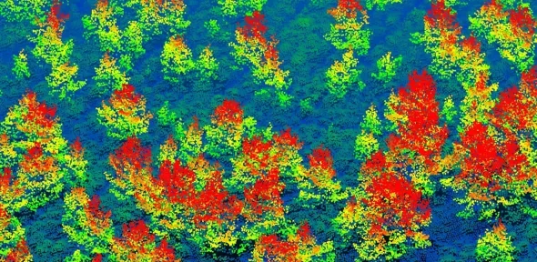
A research team from the University of Cambridge has implemented advanced aerial surveys to unveil a promising resurgence of native woodlands in Scotland’s Cairngorms National Park. This initiative, integral to the Cairngorms Connect nature restoration partnership, demonstrates how targeted deer management efforts across a sprawling 60,000 hectares are enabling tree regeneration in areas once stripped of forest cover.
Utilizing LiDAR technology from aircraft flying 600 meters above ground, the researchers created comprehensive 3D maps revealing over six million trees within a 569 square kilometer zone. These maps not only enumerate the trees but also capture height data, providing granular insight into woodland recovery.
Among the findings, 2.65 million of the surveyed trees—just above 40%—were under five meters tall, suggesting a robust pattern of natural regeneration, particularly along forest peripheries where seeds are likely to propagate. Interestingly, some new trees sprouted more than half a kilometer away from the nearest forest, hinting at an expanding forest frontier.
Notably, habitat conditions appear to influence tree establishment; areas dubbed 'bogs' have yielded fewer young trees compared to drier heathlands, highlighting the ecological complexities at play. “Mapping regenerating trees so accurately over such extensive areas represents a significant advancement in landscape-scale ecological monitoring,” states Dr. Aland Chan from Cambridge’s Centre for Landscape Regeneration, who co-led the research.
Dr. Pip Gullett, a co-author from Cairngorms Connect, emphasized the utility of the LiDAR method for monitoring both new forest growth and the detrimental impacts of severe wildfires exacerbated by climate change. “This system provides an effective framework for tracking large-scale woodland expansion, particularly as landowners across Scotland increasingly focus on reestablishing native forests,” she remarked.
Details about this pivotal research were made available in the latest issue of the Journal of Applied Ecology.
The use of airborne LiDAR technology involves firing high-frequency laser beams from an aircraft towards the ground. These pulses bounce back upon hitting trees or other surfaces, allowing researchers to construct richly detailed three-dimensional representations of the surveyed area—a method far superior to traditional ground-based survey techniques.
Validation through ground measurements confirmed the accuracy of the data acquired, and comparisons with field assessments by Cairngorms Connect and RSPB Scotland indicated that this approach can indeed reliably track forest growth on a landscape level. Although previous studies have tested LiDAR for mapping young trees, this research illustrates its potential to monitor large populations of trees in 3D, specifically to observe natural woodland expansion.
The researchers highlighted that their method could replace or significantly reduce the time and resources currently spent by staff and volunteers conducting on-the-ground site surveys. This innovative approach holds promise for forest management and restoration monitoring globally.
A Shift in Woodland Dynamics
Historically, Scotland's native coniferous forests have seen severe declines due to centuries of deforestation driven by agricultural expansion and hunting. Today, less than 4% of these original forests remain, with much of the land now characterized by heath, bogs, and grassland.
This study focuses on the Cairngorms Connect partnership, the UK’s largest contiguous nature restoration initiative, which aspires to double existing forested areas primarily through natural regeneration methods. This objective aligns with the Scottish Government’s ambition to enhance carbon capture by developing 3,000 to 5,000 hectares of native woodlands annually.
Limitations imposed by deer populations and the expense associated with deer-fenced tree planting have historically hindered woodland expansion. However, a decade into the partnership, the new findings reveal that over 5,235 hectares of land previously classified as open now supports young woodland—these areas exhibited more than 100 trees per hectare, largely due to natural seeding, with limited planting interventions where viable seed sources were absent.
Ongoing tracking of forest regeneration is imperative for effective land management. Currently, the Scottish Government is backing a national LiDAR survey, with hopes that methodologies developed in this study will contribute significantly to nature recovery efforts throughout Scotland and the broader UK.
Forested areas do more than sequester carbon; they also enhance habitats for endangered species such as the Capercaillie and red squirrels, which rely on the fragmented patches of forest that remain in Scotland.
This research is a collaborative effort by Cambridge’s Centre for Landscape Regeneration and is supported financially by the Natural Environment Research Council (NERC) along with the Endangered Landscapes and Seascapes Programme, in conjunction with Cairngorms Connect and RSPB Scotland. Tarides SAS also contributed to this work.
The study also complements a broader initiative at the University of Cambridge called Tessera, which leverages AI to analyze patterns in data from European Space Agency satellites, enabling non-experts to track forest changes over time.
Reference
S.Thapa & A.Chan et al: ‘Tracking and modelling native woodland expansion in the Scottish Highlands using LiDAR.’ Journal of Applied Ecology, Sept 2026. DOI: 10.1111/1365-2664.70561



Discussion
Sign in to join the discussion.